Location

Location

September 2, 2021 2021-09-03 12:28

Discover Thassos, the emerald island

Thassos island is paradise on earth, with a combination of crystal-clear water beaches and a mountainous landscape full of amazing pine trees, olive groves and panoramic views of the Aegean Sea. Wherever you go, you will encounter a stunning scenery, full of natural beauties and archaeological sites.

Potos is a cosmopolitan seaside village on south side of Thassos island,  famous for its nightlife and cosmopolitan atmosphere. Within a short distance, you will be able to find whatever you need during your holidays.

The southern part of Thassos is an ideal location for holidays and, combined with your stay at Velo Studios, a great option for families.

Directions

Getting here

Thassos island is only accessible by ferry boat and has two ports, Skala Prinos and Limenas (Thassos Town) which are serviced respectively from Kavala and Keramoti on the mainland.

By Boat

The fastest route is from Keramoti to Limenas (Thassos Town), with a journey time of just 35 minutes and frequent sailings, every half an hour during the summer, this is the preferred route of many visitors to Thassos. Once you get off the ferry enter the ringroad & follow the signs towards Prinos or Limenaria. Stay your course and pass through all the other villages until you reach your destination, Potos.

By Airplane

Thassos does not have its own airport but benefits from the nearby Kavala (Megas Alexandros) airport, from the airport to Keramoti port is a short taxi or hire car journey. Many tourists also choose to fly to Thessaloniki airport (International Airport Makedonia), this is the second largest airport in Greece and benefits from many budget airlines. From here you can take a bus to the coach station and from there, it is a 2-hour KTEL coach ride to Kavala, or hire a car and drive to either Kavala or Keramoti ports.

By Car

The Odos Ignatia (E90) runs across the north of Greece, from Igoumenitsa to Turkey and passes both Kavala and Keramoti.

{"settings":{"zoom":16,"mapTypeControl":false,"mapTypeId":"roadmap","styles":[{"featureType":"all","elementType":"labels.text.fill","stylers":[{"saturation":36},{"color":"#000000"},{"lightness":40}]},{"featureType":"all","elementType":"labels.text.stroke","stylers":[{"visibility":"on"},{"color":"#000000"},{"lightness":16}]},{"featureType":"all","elementType":"labels.icon","stylers":[{"visibility":"off"}]},{"featureType":"administrative","elementType":"geometry.fill","stylers":[{"color":"#000000"},{"lightness":20}]},{"featureType":"administrative","elementType":"geometry.stroke","stylers":[{"color":"#000000"},{"lightness":17},{"weight":1.1999999999999999555910790149937383830547332763671875}]},{"featureType":"landscape","elementType":"geometry","stylers":[{"color":"#000000"},{"lightness":20}]},{"featureType":"poi","elementType":"geometry","stylers":[{"color":"#000000"},{"lightness":21}]},{"featureType":"road.highway","elementType":"geometry.fill","stylers":[{"color":"#000000"},{"lightness":17}]},{"featureType":"road.highway","elementType":"geometry.stroke","stylers":[{"color":"#000000"},{"lightness":29},{"weight":0.200000000000000011102230246251565404236316680908203125}]},{"featureType":"road.arterial","elementType":"geometry","stylers":[{"color":"#000000"},{"lightness":18}]},{"featureType":"road.local","elementType":"geometry","stylers":[{"color":"#000000"},{"lightness":16}]},{"featureType":"transit","elementType":"geometry","stylers":[{"color":"#000000"},{"lightness":19}]},{"featureType":"water","elementType":"geometry","stylers":[{"color":"#000000"},{"lightness":17}]}],"zoomControl":true,"scaleControl":false,"streetViewControl":false,"fullscreenControl":false,"scrollwheel":false,"draggable":true,"center":["40.609242","24.608375"]},"marker":[{"position":["40.609242","24.608375"]}],"overlay":[{"position":["40.609242","24.608375"],"content":"\u003Cdiv class=\u0022nuss-map-overlay nuss-map-overlay- elementor-repeater-item-0f99084\u0022\u003E\u003Cdiv class=\u0022gmap-info-wrapper style-signal\u0022\u003E\u003Cdiv class=\u0022animated-dot\u0022\u003E\u003Cdiv class=\u0022middle-dot\u0022\u003E\u003C\/div\u003E\u003Cdiv class=\u0022signal signal-1\u0022\u003E\u003C\/div\u003E\u003Cdiv class=\u0022signal signal-2\u0022\u003E\u003C\/div\u003E\u003C\/div\u003E\u003Cdiv class=\u0022nuss-map-overlay-template\u0022\u003E\u003Cdiv class=\u0022nuss-map-overlay-content\u0022\u003E\u003Cdiv class=\u0022nuss-map-overlay-info\u0022\u003E\u003Cdiv class=\u0022map-marker-image\u0022\u003E\u003C\/div\u003E\u003Cdiv class=\u0022map-marker-content\u0022\u003E\u003Ch5 class=\u0022map-marker-title\u0022\u003EVelo Studios in Potos, Thassos\u003C\/h5\u003E\u003Cdiv class=\u0022map-marker-description\u0022\u003ELatitude : 40.609242 \u003Cbr\u003E\nLongitude : 24.608375\u003C\/div\u003E\u003C\/div\u003E\u003C\/div\u003E\u003C\/div\u003E\u003C\/div\u003E\u003C\/div\u003E\u003C\/div\u003E"}]}
Relaxation

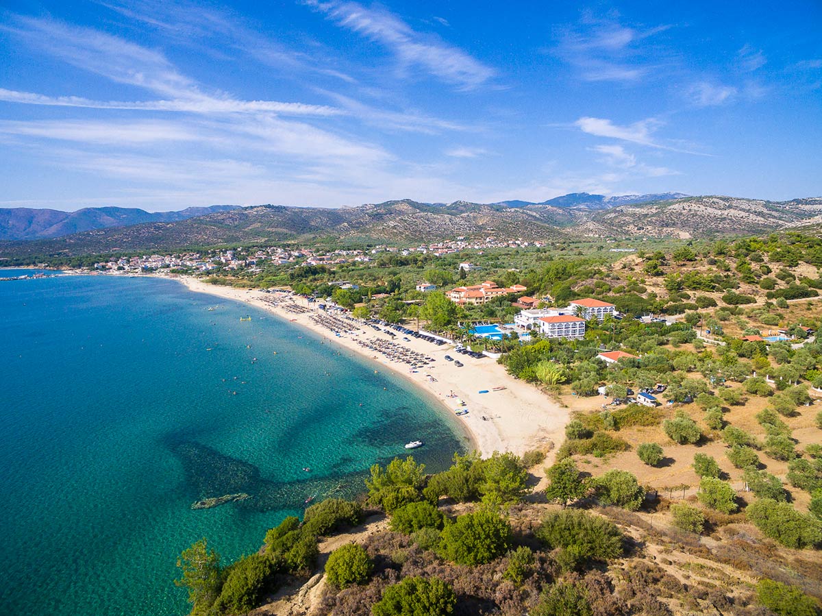
Breathtaking Beaches

Thassos is littered with dozens of amazing beaches and hidden coves all over the island, renowned for their crystal clear waters. Every visitor will find a beach of his liking to relax & enjoy, whether it is a sandy or a pebble one.

The beauty of the island is undisputed and is considered one of the most diverse and beautiful islands on the Aegean sea.
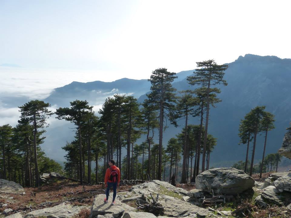
Adventure

Hiking & Cycling

Take advantage of Thassos’s old footpaths which link the traditional villages and discover the interior of the island which remains almost completely undiscovered.

Cycling is a unique way to explore the hidden and unspoiled parts of the Thassian countryside. Many biking tours are organized throughout the island.

Check Availabity

1 Room , 1 Adult , 0 Children
Rooms
Adults
Childrens
ESPA